Temperatures in the Arctic are skyrocketing — for the third time this winter
While much of the Northeast was forced to batten down the hatches this week against strong winds, heavy snow and other icy conditions, the usually frigid Arctic experienced the opposite – a period of unseasonably mild weather and high temperatures, for at least the third time this winter.
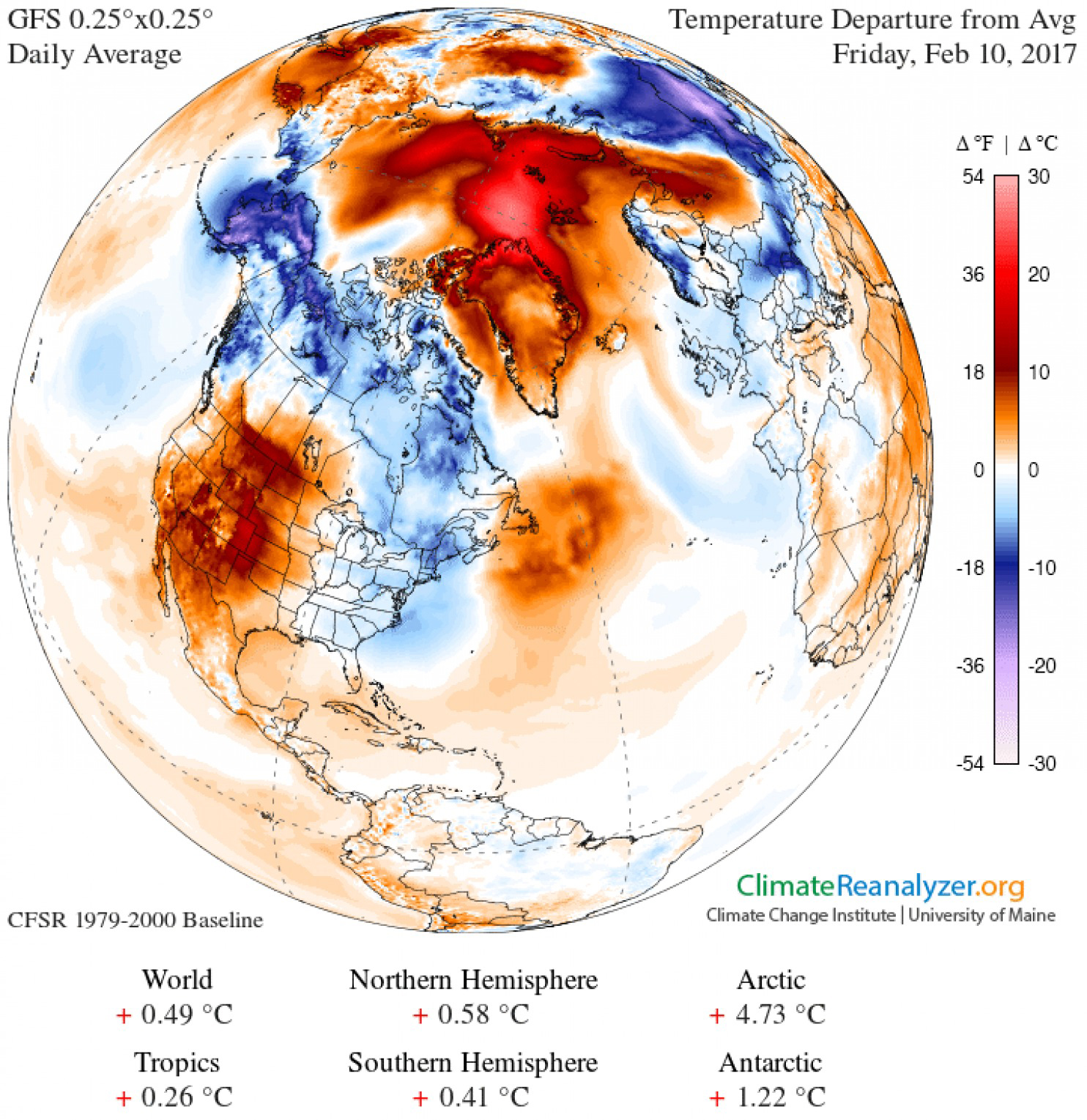
A powerful low-pressure storm system in the northern Atlantic has helped carry warm air up to the frozen north this week, sending temperatures in the Arctic soaring. Data from the Danish Meteorological Institute suggests that, as of Thursday, temperatures in the area above 80 degrees north latitude were already more than 20 degrees warmer than the average temperature for this time of year. As a graphic from Climate Reanalyzer shows, the most unusually warm region is right over the North Pole.
It’s at least the third such extreme winter-warming event for the Arctic this season – temperatures skyrocketed on two occasions in November and December as well. Similar incidents also occurred in December of 2015 and 2014.
[Alaska’s far north an outlier as January temperatures stay near historic average]
Scientists believe that a number of different factors are feeding into these warming events, including the steady march of climate change and interactions between the air and Arctic sea ice, which global warming is melting a little more each year. And a good low-pressure system, like the one that barreled through this week, can help to jump-start these kinds of sudden warming events by carrying a large amount of warm air up to the North Pole all at once.
The presence of the storm itself isn’t exactly unusual, according to atmospheric physics expert Kent Moore of the University of Toronto. Each year, there are some storms that roll through the northern Atlantic. What’s uncommon is just how far north some of them have been making it lately.
“There’s these extratropical cyclones that appear to be tracking farther north than they usually do, and these low-pressure systems are bringing the heat up into the polar region,” he said. It’s unclear why this happens, he added. But when it does, temperatures can vault up above zero degrees, or in extreme cases, sometimes even above freezing.
[Change in the Arctic this year was unlike any ever seen before, scientists say]
In a recent paper published in December, Moore notes that these types of anomalous warming events have been recorded since the 1950s – but they usually only occur once or twice a decade. Scientists believe that factors related to climate change may now be making it easier for weather systems like this week’s storm to carry warm air into the Arctic.
Changes in Arctic sea ice extent are one major issue. As a result of global warming, temperatures in the Arctic are rising at about twice the global average rate, and one of the consequences is a reduction in Arctic sea ice. These changes are most obvious in the warm summer months, when sea ice is at a minimum anyway – but lately, scientists have been observing record lows for the frozen winter months as well, a time of year when the ice is actually expanding. But where it is missing, those parts of the ocean become warmer.
“As that sea ice moves northward, there’s a huge reservoir of heat over the North Atlantic,” Moore said. “As we lose the sea ice, it allows essentially this reservoir of warmth to move closer to the pole.”
When this happens, storm systems may be able to carry heat farther north than usual. In fact, earlier this week, scientists at the National Snow and Ice Data Center announced that sea ice remained at record low daily extents through the month of January. Sea ice extent for the month averaged 5.17 million square miles, the lowest January extent on record.
[Report: 2016 was Earth’s hottest year on record by a wide margin, especially in Arctic]
Some scientists also believe that rapid warming in the Arctic has helped bring about changes in certain atmospheric patterns – causing the jet stream’s flow to become more “wavy,” for instance – in ways that can affect weather systems in the North Atlantic.
Moore noted that weather-induced warming events in the Arctic tend to be short-lived, meaning this week’s event – like similar others in the past – will probably not persist for more than a few days. But he added that an increase in the frequency of temperature extremes at the North Pole is just another indicator of climate change’s disproportionate effect on the Arctic.
“There’s more and more evidence that the Arctic, especially, is warming quite dramatically and that we should expect to see more of these events,” he said. “I think it’s just more evidence that the climate is, in fact, changing.”