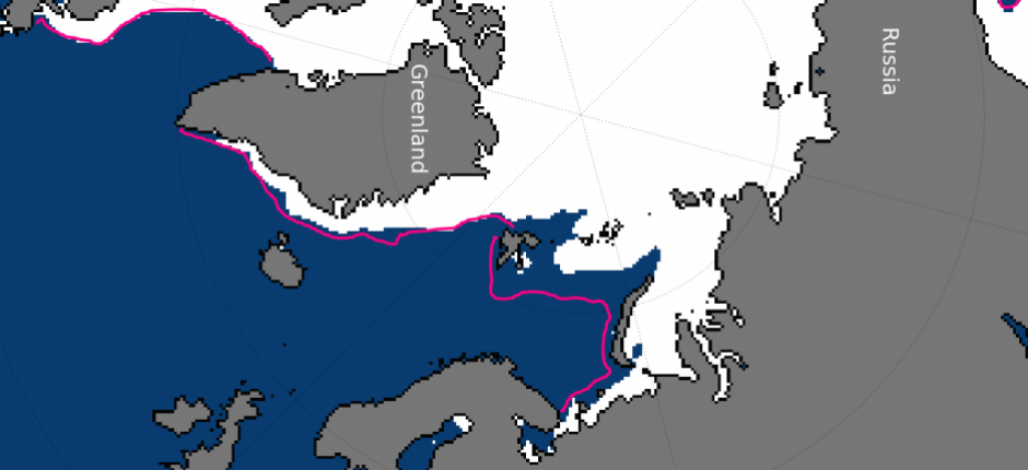
January sea-ice extent hits record low

Despite an accelerating growth rate at the end of the month, January 2017 set a record for the lowest sea-ice extent for the month, falling below the record set last year, according to the National Snow and Ice Data Center, a Colorado-based research outfit.
Continuing a pattern that started in October, daily average ice-extents were below average for most of the month, as ice-growth in parts of the Arctic Ocean north of Scandinavia and Russia stalled and even reversed during the first half of January.
Sea-ice growth this year has been hindered by three influxes of warm air that has sent temperatures near the North Pole soaring to just below the freezing point, far above the long-term average.
Climate scientists point to a variety of reasons for the incursion of waves of mild air so far north. One explanation is the unfrozen ocean water in the Barents and Kara seas. The warmer surface temperature, they suggest, allows warmer air that is normally carried toward the region from the North Atlantic to remain there for longer periods, and, in the process, spread farther north before cooling.
Such a situation allows otherwise normal weather events to become exaggerated by the effects of long-term warming that a majority of scientists believe is related to human activity.
January’s stunted ice growth was tied to higher temperatures brought on by higher-than-average sea-level air pressure over the Gulf of Alaska and the North Atlantic Ocean, which pulled warm, southerly winds into the Arctic Ocean from lower latitudes.
On average, January air temperatures were above normal for the Arctic Ocean as a whole, continuing the pattern that started last autumn, NSIDC figures show. On a region-by-region basis, however, temperature readings varied. The Barents Sea, for example, saw average temperatures that were more than 5 degrees Celsius above normal. Northwestern Russia and northeastern Greenland, on the other hand, posted below-average monthly temperature readings.
While these are the latest figures in an ominous string of monthly results, the variability of readings, Richard Cullather, a NASA scientist, told the NSIDC, make it impossible to tell whether this winter would surpass the 2015-2016 winter as the warmest on record in the Arctic.
For example, the NSIDC said changes in air pressure over parts of the Arctic Ocean indicated that cooler conditions had settled in during the month, and may have caused a sudden, rapid expansion that surpassed the rate of growth seen in previous years when January had set a record low.