As Arctic ice recedes, one of world’s strategic chokepoints opens up
ANALYSIS: A new plan for shipping lanes in the Bering Strait reveals the location's strategic importance.
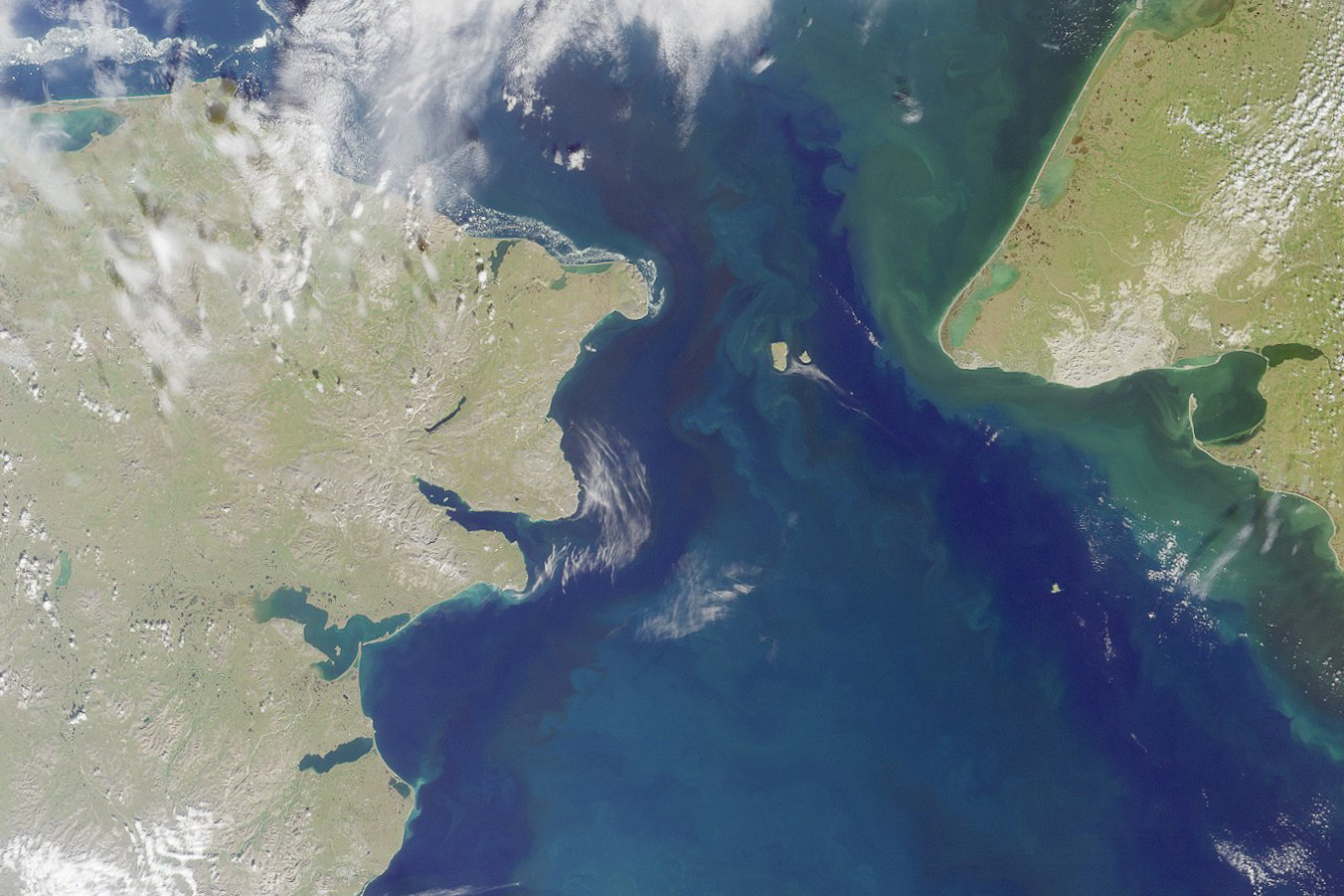
The Bering Strait has rarely been mentioned in the same conversation as the Strait of Hormuz, the Strait of Malacca, or the Suez and Panama canals.
That’s because for hundreds of years the gap between the continents was more likely to be choked with ice than ships.
But shrinking Arctic ice cover is creating open water and challenges faster than anyone would have imagined just a decade or two ago.
Summers with reduced Arctic ice have created the prospect of practical new shipping routes, which means more cargo ships, more cruise ships, more military ships and more potential conflicts in the region.
Take it as an early sign of progress that for the first time a major international organization has signed off on the designation of formal travel routes through the Bering Strait.
It has yet to become a congested waterway — even though ship traffic has doubled in the last decade — but the prospect of ice-free summers in the Arctic is a warning sign of what’s to come.
The fact that shipping lanes never existed here and that new research showed many inaccuracies of 10 to 15 percent in charted depths on the old maps are reminders of the rapid transition now taking place. Without planning and accepted rules, every shoal, reef and island is a potential catastrophe waiting to happen.
The shallow water of the eastern Bering Sea, along with a reliance on some 100-year-old hydrographic data caused the U.S. and Russia to take a conservative approach, the U.S. Coast Guard said.
The proposed shipping lanes had been surveyed with modern equipment in 2014-2015 to give planners enough confidence to declare the routes as safe.
At a London meeting in late May, the International Maritime Organization (the UN agency responsible for such things) endorsed the plan put forward by the U.S. and Russia for specific travel lanes for large ships between the Pacific Ocean and the Chukchi Sea.
Because it is recognized as an international strait, both countries allow international traffic in their waters.
The two-way travel routes are about four miles wide, one on the U.S. side of Little Diomede and one on the Russian side of Big Diomede.
There are no new aids to navigation included as part of the plan and the routes are designed to maximize the distance of ships from the shore.
“The edges of the two-way route, which will be displayed on charts or electronic chart display systems also help other vessels, such as fishing vessels, understand where they are likely to encounter other vessel activity,” the Coast Guard said in a late 2016 report.
The routes approved by the IMO are recommended for ships of 400 tons or more, but it is likely that insurance companies will require compliance to lower the risk of accidents.
The establishment of the shipping lanes comes after an official “Polar Code” for ships operating in the Arctic went into effect in 2017, with detailed rules on equipment and operations.
The expected growth of the polar route could be spurred by companies and nations looking to reduce the cost and time of travel between Europe and East Asia. The allure of passenger travel on cruise ships in formerly frozen lands will create even more challenges and unique risks from weather and communication and the lack of onshore infrastructure and emergency response personnel and equipment.
The shipping lanes avoid areas with depths of less than 60 feet and are set back from various hazards to navigation, the Coast Guard said.
The goal is to increase safety, reduce casualties and make traffic more efficient.
The agency also endorsed a U.S. request to keeps ships a safe distance from St. Lawrence Island, Nunivak Island and King Island.
The U.S. and Russia disagree on many points and there are complex unresolved military questions, but the handling of the shipping route matter provides a glimmer of hope.
It shows that both nations recognize the need to take precautions about their shared jurisdiction for a passage where the receding ice is revealing one of the world’s major strategic chokepoints.
Columnist Dermot Cole, who lives in Fairbanks, can be reached at [email protected].