🇺🇸 ANWR boundary dispute set to continue
By James Brooks, Alaska Beacon
A NINE-YEAR-OLD DISPUTE between the state of Alaska and the federal government over the western border of the Arctic National Wildlife Refuge won’t be resolved anytime soon.
On Thursday, US District Court Judge Sharon Gleason declined to issue a verdict on the dispute, and instead referred it back to a federal appeals board that has already considered the topic once before.
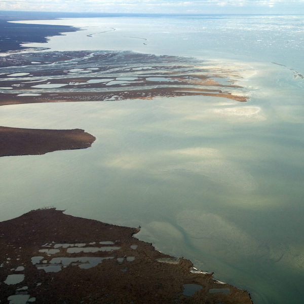
At stake are 20,000 acres of potentially oil-rich North Slope land between the Canning River and the Staines River on the North Slope.
Since 2014, the state has sought ownership of the land in order to open it for oil drilling and development. The federal government would like to preserve the land from that development.
The dispute is separate from the much larger argument about whether drilling should take placae within the wildlife refuge.a
Since the 1950s, the western boundary of the Arctic National Wildlife Refuge — and before it, the Arctic National Wildlife Range — has been defined as “the extreme west bank of the Canning River”.
The problem is that there are two different definitions of where the Canning River is. The federal government argues that decades-old maps and co-ordinates show the Staines River was defined as the boundary.
At its delta, where a river flows into a lake or sea, it can break into several “distributaries”.
The Canning River flows into the Beaufort Sea, and the Staines is the westernmost distributary, a branch that flows away from the main channel.
The state argues that the real boundary is farther east, along what maps label as the Canning River proper.
In 2016, the Bureau of Land Management rejected the state’s request to take ownership of the land between the two rivers. The state appealed that decision to the Interior Board of Land Appeals, which ruled in favour of the BLM in 2020.
Last year, the state appealed the board’s decision by filing suit in Alaska District Court, which put the issue in front of Justice Gleason. During court proceedings, the state presented 20 maps from 1951 that had not been previously considered by the land appeals board.
On Thursday, Ms Gleason ruled that evidence was significant enough that the board should look at the issue again, and she remanded the case back to the board.
Ms Gleason kept jurisdiction over the case, meaning legal proceedings could resume if the board again rules against the state.
FURTHER READING
• An environmental group plans to sue over the impact to polar bears from a new Alaska oil project
• Suddenly, new investment in Arctic Alaska oil looks very unlikely
• A new lawsuit over Arctic refuge oil cites transboundary environmental effects
• Alaska agency devotes $20 million to bid in controversial Arctic refuge lease sale
Alaska Beacon is part of States Newsroom, a network of news bureaus supported by grants and a coalition of donors as a 501c(3) public charity. Alaska Beacon maintains editorial independence. Contact Editor Andrew Kitchenman for questions: [email protected]. Follow Alaska Beacon on Facebook and Twitter.
This article has been fact-checked by Arctic Business Journal and Polar Research and Policy Initiative, with the support of the EMIF managed by the Calouste Gulbenkian Foundation.
![]()
Disclaimer: The sole responsibility for any content supported by the European Media and Information Fund lies with the author(s) and it may not necessarily reflect the positions of the EMIF and the Fund Partners, the Calouste Gulbenkian Foundation and the European University Institute.