A warm winter is coming to the Arctic
The forecast comes of the heels of a warmer-than-average summer in much of the region.
Less sea ice and more precipitation than normal can be expected in the Arctic this winter, as temperatures in the region look set stay above normal during early part of the season, says an international panel of meteorologists based on a compilation of regional outlooks.
The forecast, agreed upon during the most recent meeting of the Pan-Arctic Climate Outlook Forum, comes after a summer in which temperatures were above average over most of the Arctic.
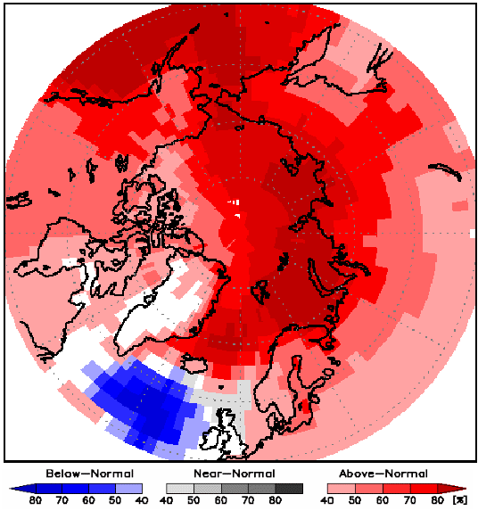
The temperature outlook for the November-January period calls for at least a 50 percent chance of warmer surface air over much of the region, with the exception of the eastern Canadian Arctic and parts of the Greenland icecap, where the chances are in the 40-50 percent range.
Sea ice
The autumn freeze-up of sea ice is expected to be earlier than normal in Hudson Bay, Baffin Bay and the Beaufort Sea, and later than normal across most of the eastern Arctic. The March 2019 sea ice extent is expected to be below or near normal.
The PARCOF outlook suggests earlier-than-normal autumn freeze-up in Hudson Bay, Baffin Bay and the Beaufort Sea, and later-than-normal freeze-up across most of the eastern Arctic from the Barents to Chukchi Seas. For the 2019 March ice extent, the expectation is below-normal ice extent in the Bering Sea and below to near normal ice extent in the Barents Sea and Sea of Okhotsk.
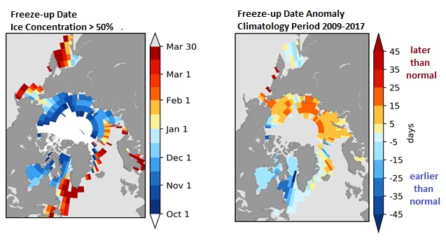
2018 outlook for autumn freeze-up by region
|
Region |
Autumn freeze-up |
Confidence |
|
Hudson & Baffin bays/ Labrador Sea Gulf of St. Lawrence Greenland Sea Barents Sea Kara/Laptev/East Siberian seas Chukchi Sea Beaufort Sea Sea of Okhotsk Bering Sea |
earlier than normal near normal near normal later than normal later than normal later than normal earlier than normal near normal later than normal |
moderate to high low moderate moderate moderate to high high high low low |
Outlook for 2019 sea-ice extent, by region
| Region | Sea-ice extent | Confidence |
|---|---|---|
| Greenland Sea | near normal | low |
| Gulf of St. Lawrence | below normal | low |
| Bering Sea | below normal | moderate |
| Barents Sea | below to near normal | moderate |
| Sea of Okhotsk | below to near normal | moderate |
| Labrador Sea | below to near normal | low |
Precipitation
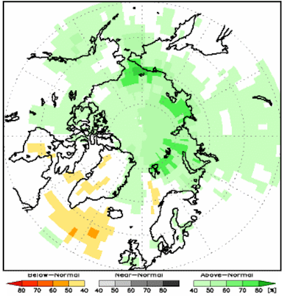
The PARCOF consensus outlook suggests that the chance of above normal precipitation is above 40 percent over the entire Canadian and Russian Arctic, with some exceptions over eastern Russia, Baffin Island and Hudson Bay, where the model was inconclusive.
Over Scandinavia, Iceland, Greenland and much of Alaska the data were inconclusive.
In the northern Atlantic region, there is at least 40 percent chance for below normal precipitation (orange areas). The area corresponds to the cold spot over the North Atlantic in the first map, and the chance of above normal precipitation is likely linked to the high probability of below normal temperatures over this region.
The Pan-Arctic Regional Climate Outlook Forum is a flagship activity of the Arctic Regional Climate Center Network. It is modelled on the Regional Climate Outlook Forum, which is supported by the World Meteorological Organization.
The second PARCOF meeting, held on October 30, brought together representatives and scientists from most of the Arctic Council members, as well as representatives from indigenous groups and shipping companies.
The first PARCOF meeting was held in Ottawa, Canada, in May.