Thaw-triggered landslides are a growing hazard in the warming North
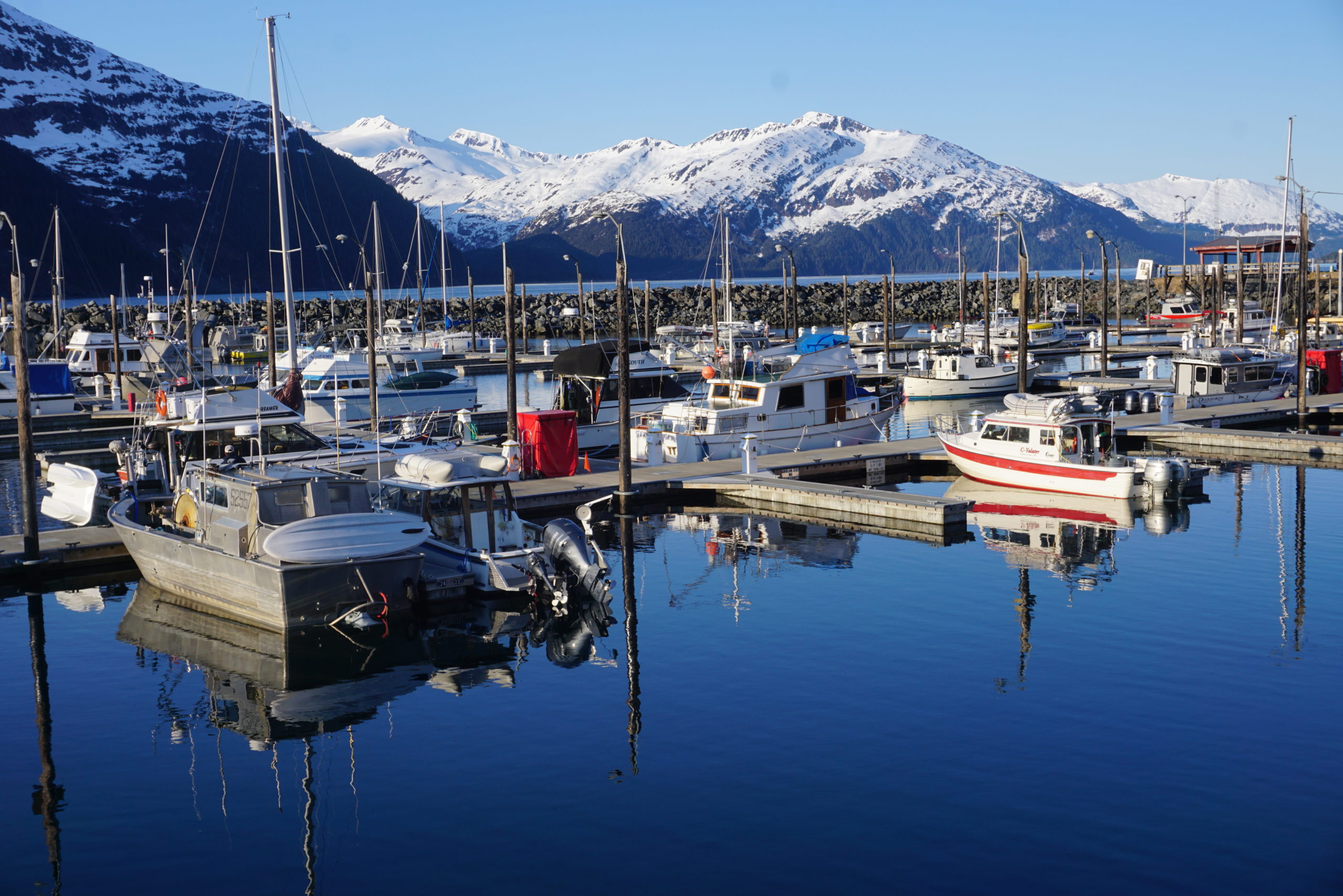
In Alaska and across the Arctic, thawing permafrost means landslides are becoming more frequent and dangerous.


The warming climate in Alaska and across the circumpolar North is creating new health and safety risks for people, animals and ecosystems. This piece is the first in a series that explores zoonotic diseases and other hazards emerging in a warming and thawing Alaska.
On a route traveled by hundreds of thousands of Alaska tourists each year, danger looms.
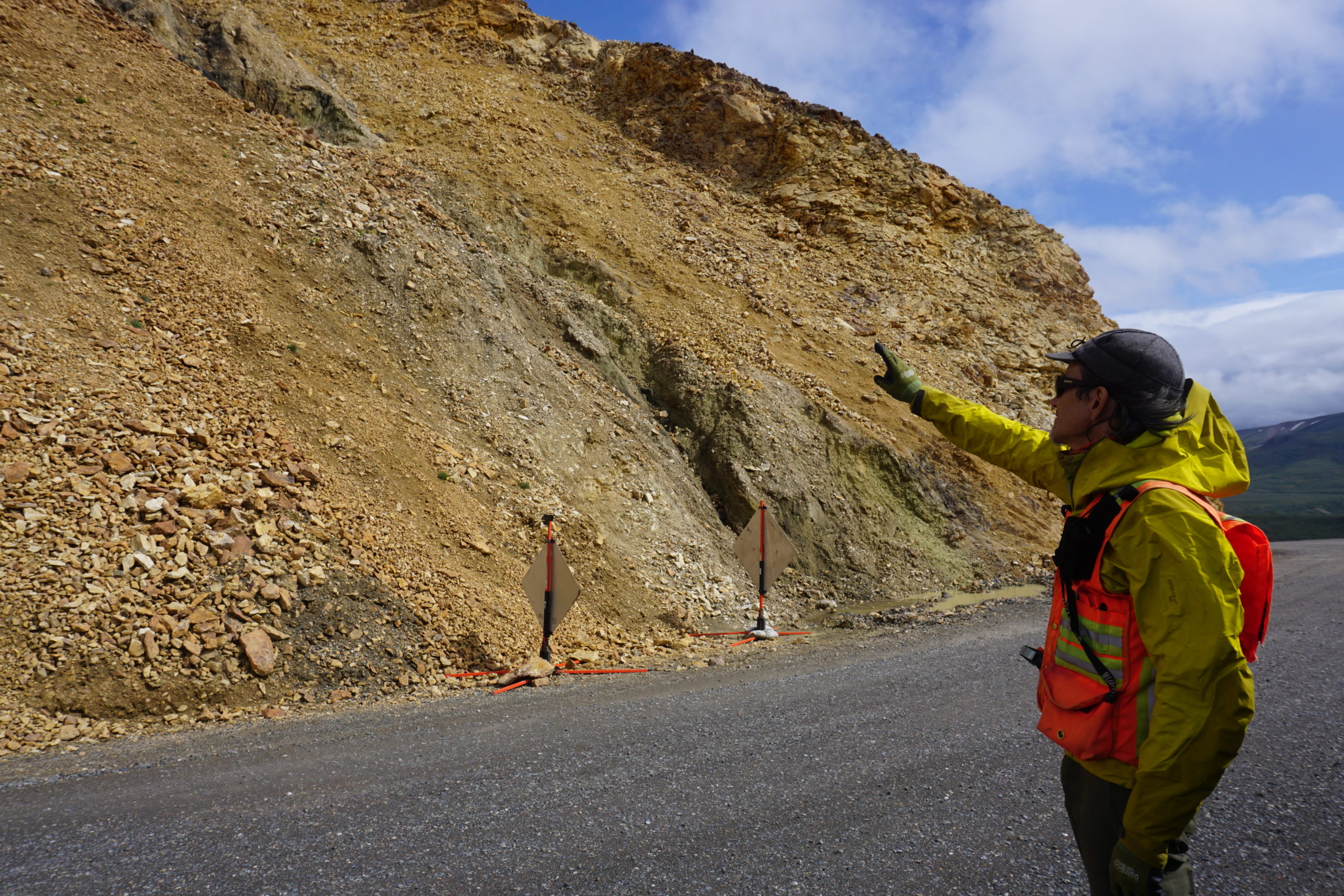
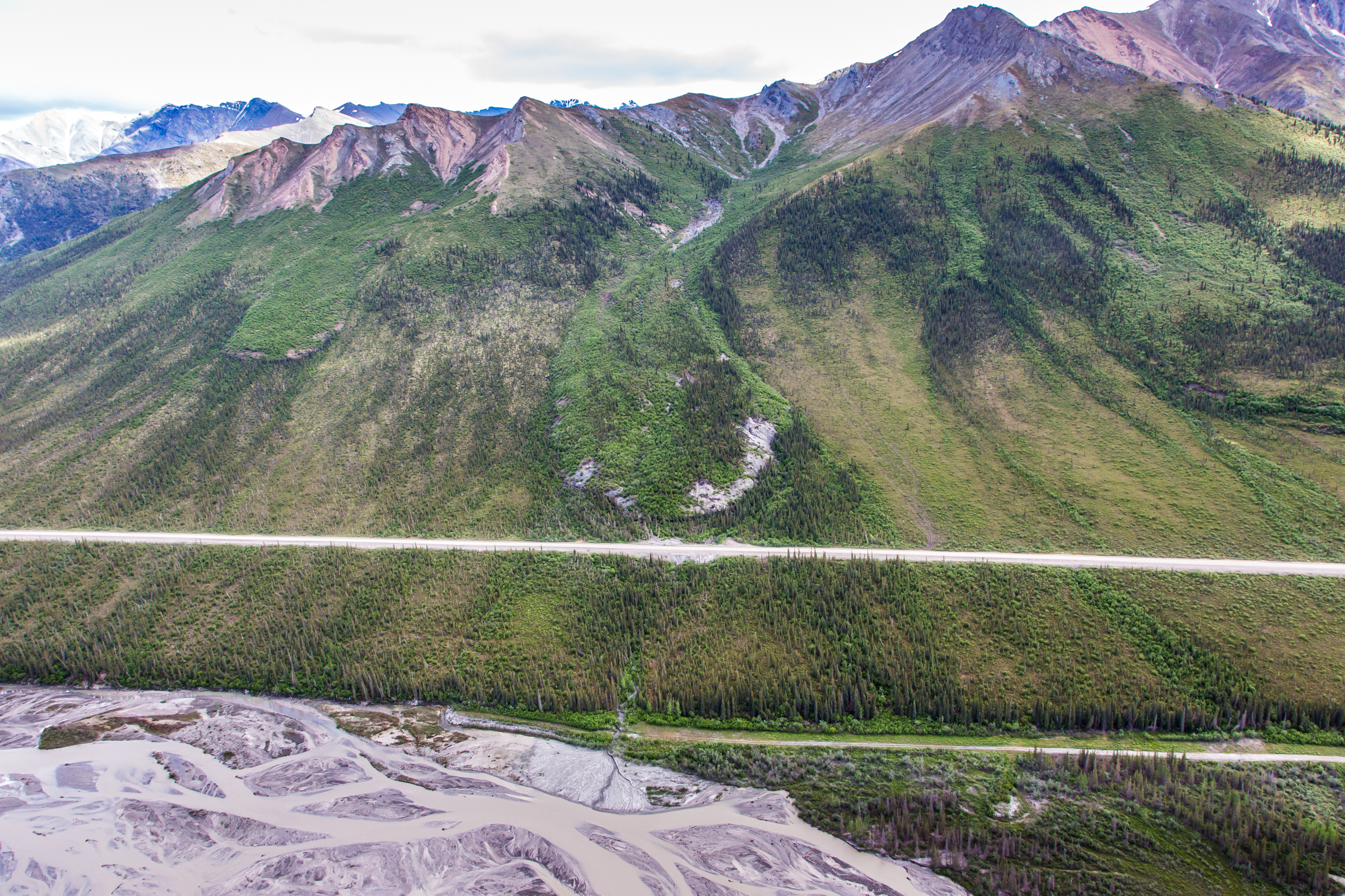
Midway along the 92-mile road that winds through Denali National Park, at a spot with an elevation of 3,500 feet and spectacular views of the Alaska Range and the braided rivers that flow out of it, an unstable wall of rock, ice, soil and clay rises precariously. The slope into which the road was cut eight decades ago is already collapsing gradually — and there are fears that it could collapse much more suddenly in the future.
The site, called Pretty Rocks, near Polychrome Overlook and along an ever-narrowing section of road perched on a steep cliff 1,000 feet above the river valley, can be nerve-wracking for travelers, most of them ferried into the park by shuttle bus. For Denny Capps, the park’s geologist, it’s a persistent source of worry.
The slope had been creeping slightly for several years, but its movement began to speed up in 2014, and it increased five-fold in the last year, Capps said. In the first seven months of the year, movement averaged about 2 inches a day for the first eight months of the year, he said. In August and early September, according to park measurements, it sped to about 3.5 inches a day.
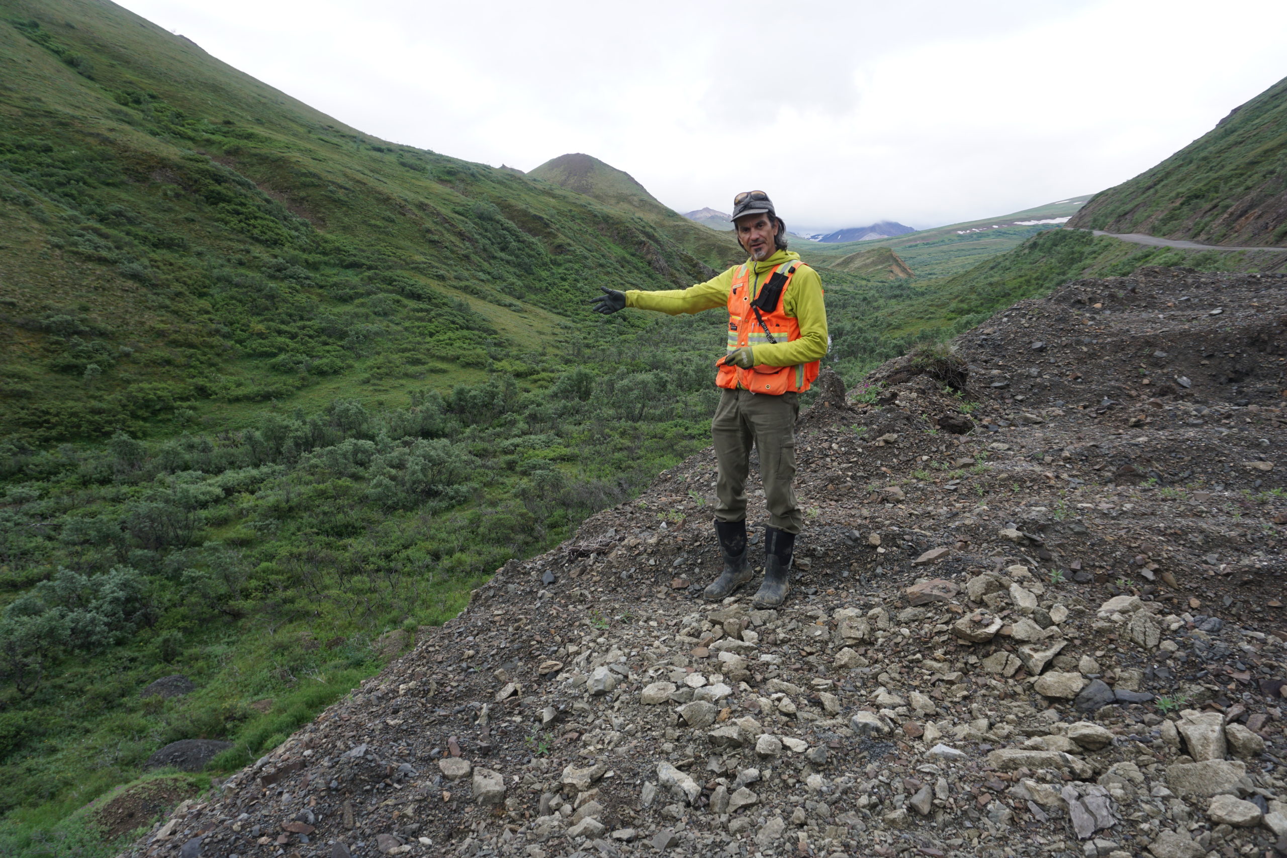
Capps comes to Pretty Rocks every few days in the tourist season to check on the rubble that routinely tumbles from the slope into a culvert dug on the inner edge of the road, the cracks that appear on the crumbling outer edge of the road and the equipment stationed to photograph and record precise movements of the slope.
“If you think in terms of maintaining a road that has buses going across it, well, that’s not easy,” he said.
Pretty Rocks, though considered the most dangerous, is just one of approximately 150 thaw-related landslides identified so far in the park. In several other places in the park, entire slopes have collapsed, leaving bare dirt exposed and sending patches of alpine tundra askew.
All this makes Denali a case study for thaw-triggered landslides that are becoming an increasing hazard across the Far North.
There have already been major slides that have snarled park road traffic. One was at Igloo Creek, at mile 38. In October of 2013, part of the slope collapsed with what the Park Service has described as house-sized chunks of dislodged permafrost blocking the road.
Luckily, Capps said, that slide was after the end of the summer tourist season. “It was like a warning shot across the bow,” he said. “It could have knocked a bus off the road.”
Much of the frozen terrain in the park is doomed, scientists have warned.
A 2014 study on Denali’s permafrost estimated that about half of the park’s terrain was underlain by it but that almost all will be gone by the end of the century. The study, by University of Alaska Fairbanks scientists, predicted that in 2100, only 1 percent of Denali will still have permafrost, with remnant traces at high elevations and north-facing spots.
If anything, those predictions now appear optimistic. The warming trend that has been documented since the 1920s took a dramatic turn after 2013, Capps said. “It was like a switch,” he said. Average temperatures at two key park sites rose 4 degrees Fahrenheit from 2014 to 2019, reaching levels not expected until about 2040, he said.
Warming does more than increase air temperatures. Rainfall has increased in Alaska, too.
In non-permafrost areas, rain is a well-known trigger for landslides, like those that ravaged southeast Alaska during a record-breaking early December storm, causing two presumed deaths in the coastal town of Haines. Winter rains also triggered the devastating Dec. 30 mudslide in the Norwegian village of Gjerdrum that killed 10 people and temporarily displaced about 1,000.


But rain also hastens permafrost thaw, as research led by the U.S. Army Cold Regions Research and Engineering Laboratory has shown. Precipitation — which appears to be underappreciated — might be even as important to permafrost degradation as surface air temperature is, concludes a recent study by scientists from the Lawrence Berkeley National Laboratory, the University of Alberta and UAF permafrost expert Vladimir Romanovsky.
“We conclude that increases in precipitation under 21st century warmer climate will hasten permafrost degradation through increases in heat transfer from warmer precipitation, soil thermal conductivity, and thus rapid downward soil heat fluxes,” says the study, published in January in the journal Environmental Research Letters.
Rain has made its mark on Denali landslides. A July 2016 slide that dumped debris a 4-meter-thick layer on the park road at mile 67, closing that section for 10 days — and stranding some tourists — was triggered by heavy rain.
Throughout the circumpolar North, thaw-induced slides are increasingly recognized as a public safety threat.
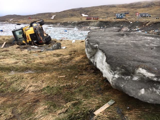
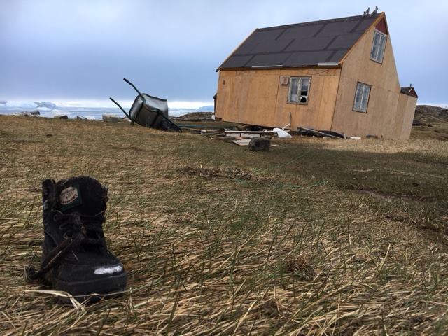
A 2017 landslide that roared down a slope in Greenland — in a place where slides had not been previously known — triggered a localized tsunami that killed four people and destroyed 11 buildings in the fishing village of Nuugaatsiaq.

In Alaska’s Glacier Bay National Park in southeast Alaska, a U.S. Geological Survey-led review of large rock avalanches unconnected to earthquakes found the risk doubled over the past three decades – a change concurrent with rising temperatures.
On Banks Island in Canada’s Arctic, there was a 60-fold increase from 1984 to 2015 in landslides caused by thaw of permafrost ground ice, according to a study published in 2019. The study, by Antoni G. Lewkowicz of the University of Ottawa, examined more than 4,000 retrogressive thaw slumps, landslides caused by thaw in ice-rich permafrost.
A surprise landslide emerged even near Alaska’s biggest city. A May 2020 slide that followed a period of sudden warmup gouged out a section of mountain slope near Alyeska Resort, a 40-mile drive south of downtown Anchorage.
Vulnerability to thaw is widespread
Thaw-vulnerable slopes hold varying compositions of ice, rock, dirt and sometimes clay, but they have one thing in common: They are at increasingly at risk of collapse as the climate warms.
The lines between categories of frozen material can blur, said Jeff Coe, a Colorado-based USGS research geologist who has led a lot of the research at Glacier Bay.
“There’s a lot of overlap that’s going on at the same place,” he said.
There is yedoma, a category of permafrost that is at least 50 percent ice and is found in high-north spots like coastal Siberia and Alaska’s North Slope. It is at risk of sudden thaw because of its ice content and is characterized by ice-wedge polygons that are changing rapidly with thaw, along with sinkholes that are opening up on tundra landscapes.
There is tundra and boreal permafrost, subjected to both gradual, long-term warming and abrupt thaw from events like wildfire and erosion. Those thaw events are worrisome because of the potential for releasing high amounts of carbon long sequestered in the soil.
Mountainous areas hold their own varieties of alpine permafrost, which can be found at latitudes well below the Arctic Circle.
There is rock permafrost, which like the more commonly understood soil permafrost, is defined by a temperature that remains below freezing year-round. Rock permafrost can be held together with veins of ice, or it can even exist with almost no ice at all.
There are rock glaciers, which include the slipping slope at Pretty Rocks. “It’s debris that’s kind of glued together with ice,” said Louise Farquharson, a research professor at the UAF Permafrost Laboratory who is doing work in Denali to ground-truth projections about freeze and thaw conditions.
And there are the more conventional glaciers that, through their melt, are helping trigger landslides. In coastal areas, those slides can produce tsunamis, as the 2017 Greenland disaster demonstrated.
A 2015 collapse of a mountain face at Taan Fjord in Alaska’s Wrangell-St. Elias National Park dumped 180 million tons of rock and debris into the water. The biggest non-volcanic landslide on record in North America, it caused a local tsunami rising up to 193 meters, the fourth-highest ever recorded. The triggering event is believed to retreat of Tyndall Glacier, weakening that ice mass’ function as a buttress to the mountainside. There were no people in the area when the slide and tsunami ripped through, unlike the case at Karrat Fjord in Greenland, but the event sent a warning to anyone traveling in Alaska’s mountainous terrain.
Attention has now turned to a potentially catastrophic collapse at a mountainous spot in Prince William Sound that would dwarf the Taan Fjord landslide. At Barry Arm, a fjord popular with fishermen, tourists and recreational boaters, the exposed mountain face is in danger of peeling away and dumping enormous masses of rock – up to 500 million tons, geologists estimate. A resulting tsunami would endanger the town of Whittier, with about 200 year-round residents and hundreds more summer visitors, about 50 kilometers away, they warn.
Discoveries this year of slope movement at Barry Arm snapped officials into action; a monitoring network making use of satellite data was quickly erected on the stop. The system is now providing its first readings; it measured an 8-inch movement in three weeks in October. It is difficult to tell whether permafrost thaw or glacier melt is the most significant contributor to landslide risks on coastal mountains, said Coe, lead author of the 2017 Glacier Bay study.
His research so far suggests that the thaw-induced weaknesses near the top of mountains may be more important causes of major landslides than the melt of glaciers at the bottom, he said.
“The recession of the glacier might just be the tipping point that pushes it over the edge,” he said. “That may be part of the reason it fails, but that may not be the important reason why it fails.”
A high-elevation landslide this summer on the mountain wall above Barry Arm, for example, supports the idea that thaw near mountaintops is a more dangerous trigger.
Another risk factor in high-latitude landslides is vegetation cover – specifically, in high latitudes where the treeline is low, the lack of it. Bare slopes on mountains lack the plant and peat layers that help insulate permafrost, Farquharson said. “So the ground temperatures respond much more quickly to air temperatures,” she said.
Warning systems are difficult to assemble
The mountainous areas of the North — and Alaska in particular — need a much more robust landslide monitoring network, Farquharson, Coe and other scientists argue.
“Alaska’s kind of a landslide frontier,” Coe said.
A network in Alps demonstrates that it is possible to punch sensor boreholes into rock permafrost and high-mountain permafrost, but Europeans have some access and infrastructure advantages that Alaskans lack, she said.
The UAF Permafrost Laboratory, a world leader for its work on tundra and boreal permafrost, is just starting to turn its attention to harder-to-reach mountain permafrost, Farquharson said. But UAF does not yet have enough of the appropriate equipment to monitor those less-accessible high-latitude areas, she said.
There are ways to track the movement of slide-vulnerable slopes from afar, including aerial photography and remote sensing technology like LiDAR. Scientists at Columbia University’s Lamont-Doherty Earth Observatory, scientists developed a system of seismic measurements to track massive landslides in remote areas — distinguishing landslide seismic signals created by landslides from the jolt-like signals produced by earthquakes. Their analysis of seismic signals led to discoveries of massive landslides in the mountains of southeast Alaska and neighboring parts of Canada.
In Alaska, efforts to detect landslide risks should focus on places where people are put at risk, experts say. To a large extent, that means areas with roads.
The Dalton Highway, the sole road that connects the North Slope oil fields with the outside world, already has a problem with slow-moving “frozen debris lobes” – mixtures of soil, vegetation and ice – that are creeping down the slopes of the Brooks Range. The Alaska Department of Transportation and Public Facilities has already spent millions to reroute a section of the road away from the oncoming icy blob, buying a few more years’ time to plan the next escape from the sliding blobs.
An Alaska road not yet built also faces risks from thaw-triggered landslides. The controversial Ambler Mining District Industrial Access project, proposed to run 211 miles to an isolated mineral-rich district in northwest Arctic Alaska, would thread near south-facing slopes of the Brooks Range’s mountains. The possibility of permafrost thaw-related slides gets some oblique mention in the project’s environmental impact statement. “Cut slopes exposing ice-rich permafrost are particularly susceptible to erosion,” and protective measures are warranted, warns the Bureau of Land Management EIS, issued last spring.
For now, Denali – one of Alaska’s top tourist attractions and visited by over 600,000 people a year – is an obvious high-priority site for protection.
Park managers have a strategy. In the short-term, they will continue maintenance tasks like the regular emptying of emptying the debris-catching culverts dug along the roadsides. An ambitious long-term vision includes a new suspension bridge across the entire Pretty Rocks area or, if that is not possible, a complete rerouting of that section of road. In all, costs for addressing roadside landslide risks could total over $300 million, according to current park estimates.
The challenge is daunting, said Farquharson, who will be back to drill more boreholes there this summer. “It seems like they really have their work cut out for them keeping that road open,” she said.
This story was supported by the Society of Environmental Journalists’ Fund for Environmental Journalism and the International Women’s Media Foundation Howard Buffett Fund for Women Journalists.