Terrain, lack of freshwater and uneven snow will make Arctic refuge winter travel difficult, scientists warn
Elsewhere on Alaska's North Slope, oil companies rely on ice roads. In the Arctic National Wildlife Refuge, that might not be an option.
In their argument for oil drilling on the coastal plain of the Arctic National Wildlife Refuge, supporters invoke oil companies’ experience of using seasonal ice roads as evidence of a “small footprint” that development would create.
“The ice pads and roads literally melt and have zero impact on the tundra. The only thing left is a small capped well,” Sen. Dan Sullivan said, touting “no-impact” winter-only exploration, said in Senate testimony in late 2017. In an op-ed column published subsequently in the Washington Post, Sullivan made a similar argument.
There is a problem with that pitch: The conditions that allow companies to build big networks of ice roads that protect tundra elsewhere on the North Slope do not exist in the refuge’s coastal plain, scientists say.
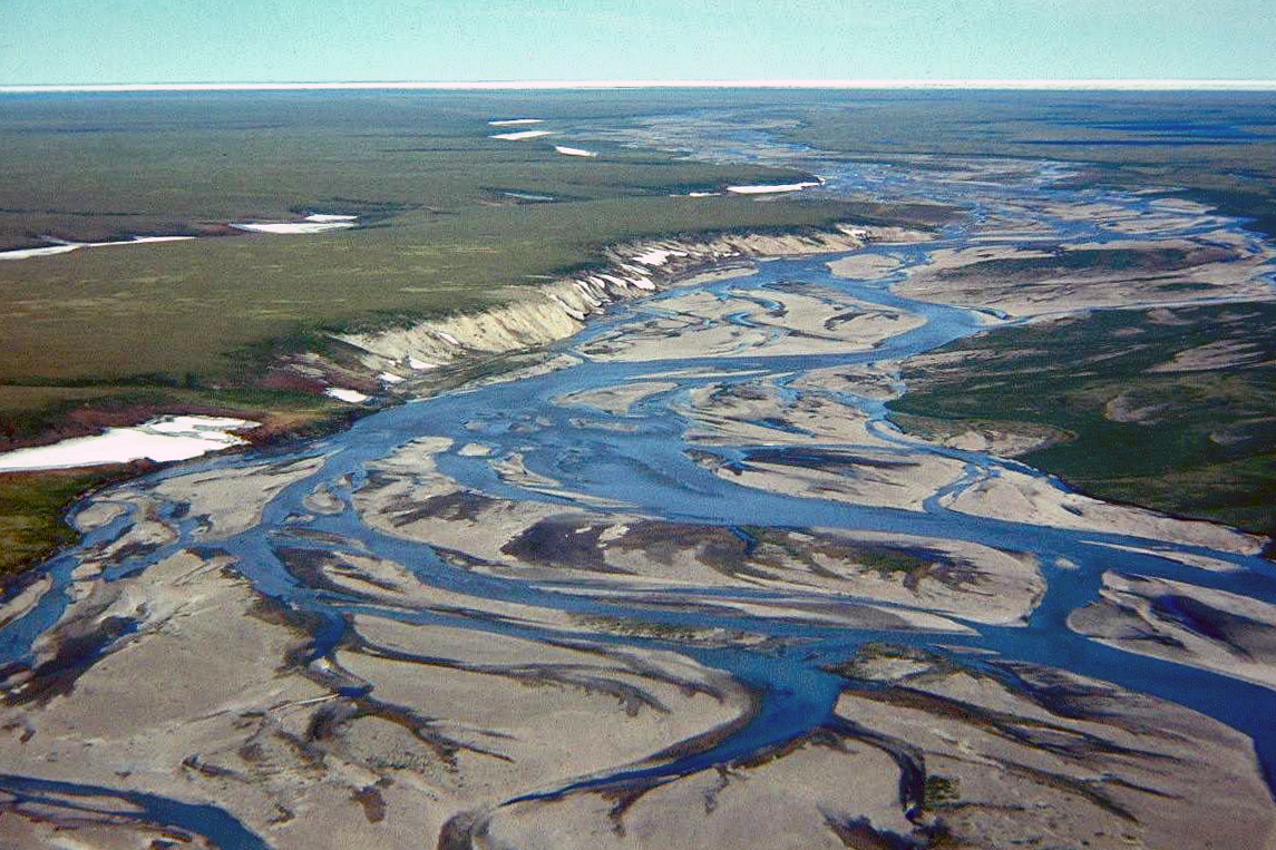
The narrow wedge of land that comprises the refuge’s coastal plain — where in some spots the mountains are less than 20 miles from the sea — lacks the abundance of fresh water found elsewhere on the North Slope. And the sloping and highly textured terrain, swept by high winds that scour parts of the tundra nearly bare of snow and dump piles in other spots, create conditions unlike those elsewhere on the North Slope’s coast.
That makes the region, referred to as the 1002 Area, after its legal designation, less like the developed parts of the North Slope and “more akin to the Foothills than the coastal plain,” said a summary report from a scientific snow workshop held last October in Fairbanks.
The “Foothills” references an area further west in the foothills of the Brooks Range that has also seen oil exploration, and for winter tundra travel, the comparison is not encouraging. In recent years, soil freeze and snow conditions in the Brooks Range foothills have rarely reached thresholds adequate to allow industrial tundra travel.
The last time both the upper-elevation and lower-elevation foothills had enough snow and hard-frozen soil to support winter travel by heavy vehicles was 2014. In the years since, one or more parts of the foothills have been closed all winter to industrial travel, under rules enforced by the Alaska Department of Natural Resources,
This winter was no exception to the trend. On March 13, DNR’s Land and Water Division announced that snowpack had missed the 9-inch-thickness threshold in both the upper and lower foothills regions, and in one key spot, the soil temperature failed to fall to the required threshold of minus-5 degrees Celsius.
The federal government should recognize that the foothills-like conditions on the Arctic refuge coastal plain cannot support the same kind of oil-industry traffic that is routine elsewhere on the North Slope, said Matthew Sturm, who heads the snow-ice-permafrost research group at UAF’s Geophysical Institute and who organized the October workshop.
“It’s all well and good for the nation to make resource decisions. I’m all for that,” Sturm said. “But we begin to make decisions that are not rooted in the reality of what’s on the ground, then I think it’s the job of scientists, as sort of honest brokers to say, ‘This is what the landscape is like, this is what the snow is like.’”
Conclusions of the October workshop were reached by consensus from all attendees, Sturm said. Those included officials from the Bureau of Land Management, the federal agency that is overseeing the oil leasing plan, he said. The BLM and the U.S. Fish and Wildlife Service, which manages national wildlife refuges, were sponsors of the workshop.
The BLM, in its draft environmental impact statement about upcoming oil leasing, acknowledges the area’s lack of freshwater sources for future ice roads.
Although most of the 1002 Area is considered permafrost, “lakes are very scarce,” comprising less than 2 percent of the land surface, the BLM’s draft EIS says. That compares to conditions far to the west, in the National Petroleum Reserve in Alaska (NPR-A), where oil companies are active in a region where lakes cover 20 percent of the surface area, the draft EIS says. What lakes do exist in the refuge coastal plain “are not evenly distributed across the program area” but concentrated near river mouths. Even among those lakes, a small number combined hold about 80 percent of the coastal plain’s water, and one of those “is known to have salinity close to that of saltwater,” which cannot be used for ice roads. And what water does exist in the remaining lakes is almost entirely frozen solid in winter, creating a further challenge to ice road construction.
So where will companies get the water they need to build ice roads in the ANWR coastal plain?
“That’s the big question. We really don’t know. There aren’t many lakes, and that’s where most water comes from for ice roads on state land,” said Melissa Head, a DNR resource manager who oversees tundra-travel permitting. Alternative sources of water, such as massive amounts of snowmelt or desalination of ocean water, would be extremely expensive, she said. “I don’t really see the use of ice roads being a big use out there,” she said.
Companies that can’t build a large network of ice roads in ANWR might have to rely on barges traveling up to the Beaufort Sea in summer and, potentially, on roads built up with snow, she said.
“They might have to figure out a way to make do with snow roads. The actual vehicles and rigs might have to change,” Head said.
Snow roads cannot support most heavy industrial traffic, but they can be used by some specialty tracked vehicles and by snow-moving, soft-wheeled “rolligons.”
Even snow roads on the ANWR coast would be problematic, scientists say.
The sloping terrain of the area is cut sharply with incised creeks, creating an uneven terrain where deep snowdrifts gather in some spots while other spots are swept nearly bare of snow, Sturm said.
The extremely high winds, funneled by the mountains that loom over the coast, are also different from what exists elsewhere on the North Slope coast, said Rick Thoman of the Alaska Center for Climate Assessment and Policy.
In Utqiagvik, about 300 miles west of the refuge coastal plain, “the winds almost always blow, but it’s rarely very strong in the winter,” Thoman said. In the 1002 Area, the pattern is much different, he said. “They do get periods where there’s not much wind, but they also get these extreme events,” he said. He cited a 2015 windstorm in the village perched on the edge of the refuge coastal plain, Kaktovik. That storm, with hurricane-force winds that tossed Dumpsters down streets and sent villagers to the school to take shelter.
Decisions about companies’ future tundra travel will be made on a case-by-case basis, said Nicole Hayes, the BLM project manager for the oil leasing EIS. That includes plans for ice roads and pads, she said. “The actual amount and source of water used would be project specific and would be based on project location, best management practices, new technology, and the specific needs of the project, such as the width of ice roads, number of camps, number of crew, and ice pad size. This would be analyzed in detail when a site specific proposal is received,” she said in an email.
There is some urgency to the question of tundra travel in ANWR.
A large-scale 3D seismic survey is pending for next winter. The proposal, by SAExploration, would send a fleet of heavy trucks shooting sound waves into the ground earth to better define geologic structures. SAExploration had sought to start its program as early as last December, timing that was the impetus for October workshop, Sturm said.
“That pressure was not helpful to anybody. I know where it came from and I don’t want to get into politics, but that sort of high-pressure situation does not lead to good management of anything,” he said. SAExploration failed to secure permits for seismic work in the winter of 2018-19, but is seeking permission to start up next winter.
The idea of seismic “thumper trucks” rumbling over the ANWR coastal terrain before further studies have been done is alarming to several senior UAF scientists, including Sturm.
They co-authored a white paper released in January that urges a slowdown to a seismic program that would create about 61,000 kilometers of seismic trails “in one of the most sensitive protected areas in the circumpolar Arctic.”
The authors include experts in permafrost, hydrology, Arctic botany and other disciplines. The first author, Donald “Skip” Walker, is UAF ecology professor with half a century of experience studying Arctic tundra and vegetation.
In their white paper, they describe a highly variable snow cover, extreme wind conditions, complex terrain and different vegetation and permafrost conditions than exist in North Slope areas to the west. Seismic surveys, as currently planned, would create a “checkerboard” of long-lasting scars on the tundra there, the white paper says
“The 1002 Area is topographically and biologically distinct from the rest of the North Slope. The diversity of geology, topography, soils, snow regimes, and vegetation create a mosaic of habitats that accounts for the high biological diversity of the 1002 Area. The impacts from surveys in this terrain will likely have long-term significant impacts to the area’s hydrology, permafrost, vegetation, and ecosystems,” the paper says.
An important feature of the ANWR coastal plain is its ice-rich permafrost, according to the white paper. The area is underlain with yedoma, a type of permafrost with a composition that is at least 50 percent ice — and is particularly vulnerable to disturbance thaw.
One top official in the Department of the Interior was unswayed by the white paper.
The department is reviewing the white paper “to see what it adds to our understanding and, you know, whether it’s a valid scientific paper,” Joe Balash, Interior’s assistant secretary for land and minerals management, told reporters at a public meeting held by the BLM on Feb. 11 in Anchorage.
The white paper “starts with the intent” of calling for a full environmental impact statement on the proposed seismic program rather than the more cursory environmental assessment that the BLM is currently leading, Balash said. He questions its credibility, he said.
“It appears to be, on its face, anyway, something that has a specific purpose and agenda. That’s not really the way science is conducted. Normally you start out with a hypothesis, gather your data, test it against your hypothesis and report your results,” he said. “So I come to it with a little bit of skepticism. But we’ve got scientists of our own, hydrologists, botanists, that will help us understand if the contents have any merit.”
In one important way, the ANWR coastal plain and the rest of the North Slope coastal plain are similar. In both areas, winters are getting shorter and less cold, a change tied to retreat of Arctic sea ice.
Shorter winters have resulted in shorter tundra-travel seasons.
On the developed part of the North Slope coast, a tundra travel season that was regularly 200 or more days a year in the 1970s is now only about 110 to 150 days a year, according to DNR statistics. In recent years, companies have taken special measures, like pre-packing snow to serve as road platforms, to stretch the tundra travel season.
Tundra travel is crucial to oil companies, especially those exploring and developing in the western part of the North Slope, an area teeming with new discoveries and prospects but distant from older Prudhoe Bay-area infrastructure. This winter, companies have built or are planning to build about 150 miles of ice roads and about 75 acres of ice pads, according to DNR. Additionally, oil companies plan to use about 500 miles of snow roads to support various winter operations, according to DNR.
There were no plans for industry tundra travel this winter in the less-prospective Brooks Range foothills, according to DNR. There, the winter travel season – when it occurs – has shrunk dramatically in past decades. The most recent travel opening, in the lower foothills in early 2018, lasted for 56 days, according to DNR. The previous opening, in the upper foothills in early 2017, was 49 days.