Swiss-Danish expedition finds the world’s northernmost island
We didn’t know until we got home that we had discovered what now seems to be the northernmost island on Earth.
We were a team of five from the Leister Expedition Around North Greenland 2021, a Swiss-Danish scientific expedition, that landed on the island in a small chartered helicopter in late July.
We were convinced that we had landed on Oodaap Qeqertaa — or Oodaaq Island — an islet north of Greenland first sighted in 1978 by Danish geodesists and identified as the northernmost of its kind.
It was approaching midnight, when, unhindered by fog or any other onslaught of nasty weather, we set out from our quarters at a mining camp in Citronen Fjord.
Parts of our team flew in a Twin Otter toward Cape Morris Jesup, the northernmost tip of Greenland’s landmass and thus the northernmost point of land in the world, while the rest of us made a detour with the helicopter trying to locate Oodaap Qeqertaa and, if possible, make a brief landing there.
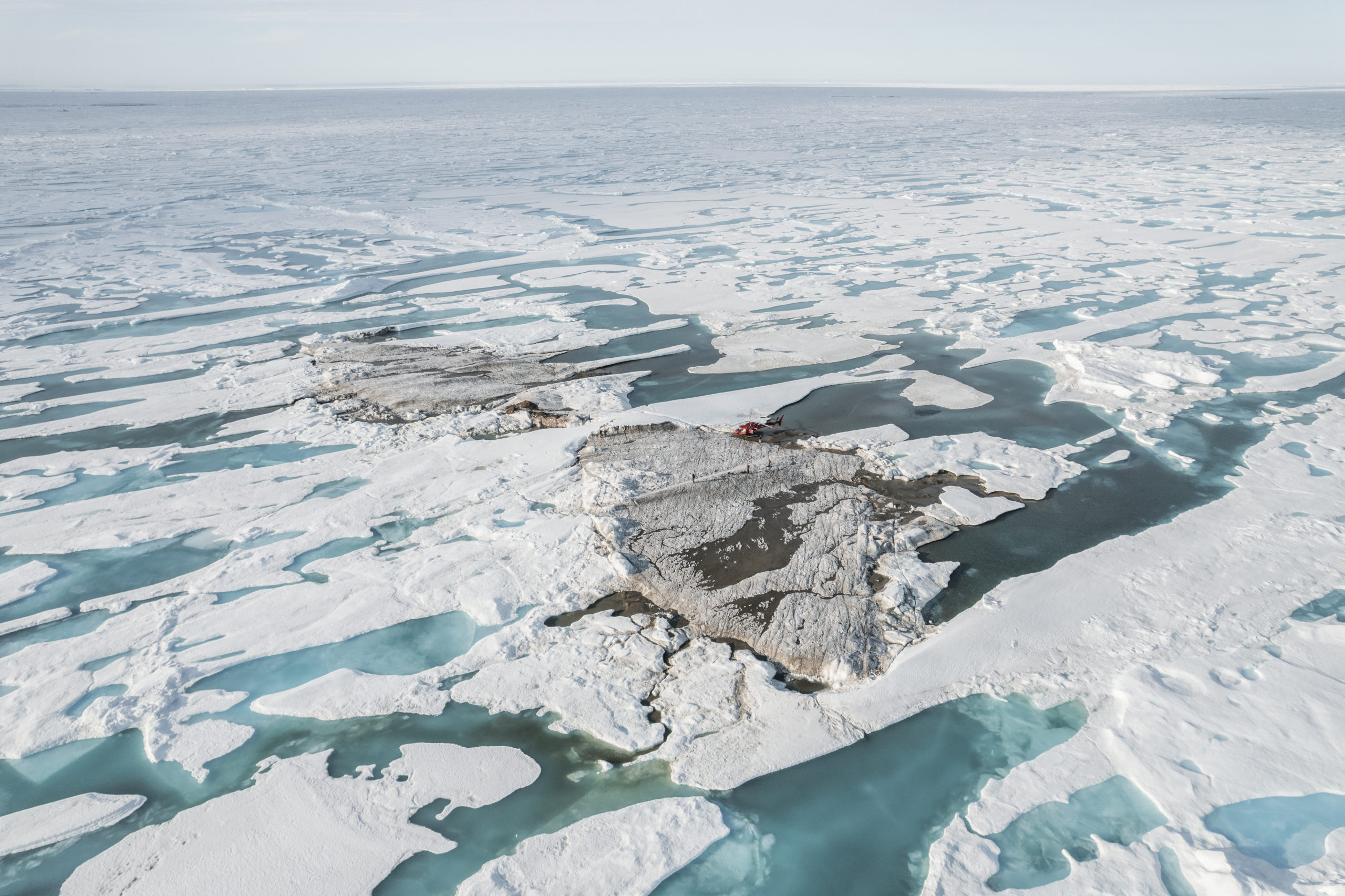
We flew for about an hour over the wondrously majestic mountains of Pearyland, Greenland’s northernmost glacier-graced region, and then conducted a brief search of the shallow waters beyond of the flat reaches of northern Greenland’s coastal planes. Above the icy waters, resplendent in the late-night sun, the pilot soon spotted what we all agreed had to be Oodaap Qeqertaa.
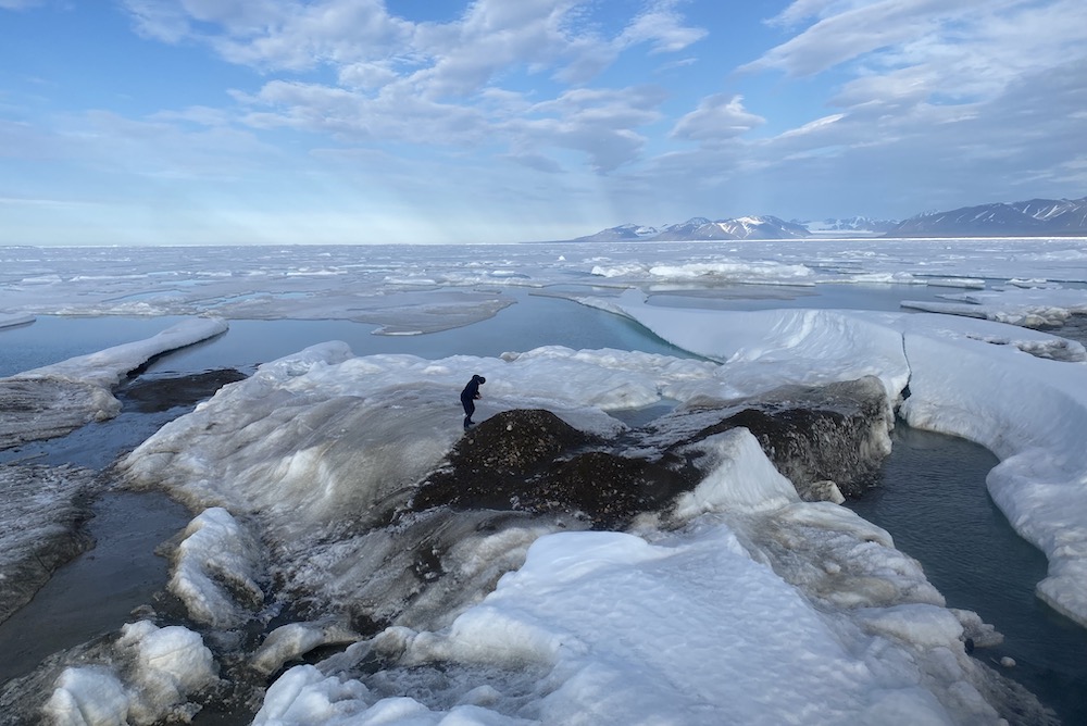
The pilot scanned the area for polar bears and then landed on this otherwise stark, unassuming bank of gravel, sea ice, windblown snow patches, yellowish mud and a number of cone-shaped piles of gravel and rock, each standing a meter or two high. The coordinates on the helicopter’s instrument panel told us that we were at 83° 40′ 59.1″ North and 030° 41′ 52.2″ West. The precise size of the islet was hard to ascertain as it was ringed by ice, but I guessed it was less than 30 meters from one end to the other; other members of our group later suggested it was somewhat larger.
We didn’t spend much time there, less than an hour, but, as I related in an earlier account, we managed a brief ceremonial swim; it wasn’t particularly pleasant, but it was a fitting gesture to mark a special moment.
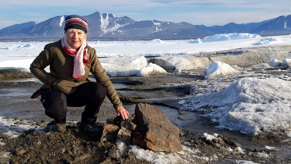
A camera drone was launched, a small cairn was built and a notice left in the name of the expedition. Our expedition coordinator, Morten Rasch, a Danish coastal geomorphologist, waved a Greenlandic flag. Oodaap Qeqertaa was named after one of the legendary Greenlandic sled pilots from the Thule district, indispensable as they were to the early mapping of northern Greenland in the first part of the 20th century.
Not Oodaaq after all
It wasn’t until a couple of weeks later, when we had returned home, that we discovered to our surprise that we hadn’t been where we thought we were.
It began when an old acquaintance, Rene Forsberg, a professor at DTU Space, the Danish national space institute, heard through the grapevine about our expedition and the trip to what we at the time thought was Oodaap Qeqertaa. He wrote to ask for the precise coordinates of our helicopter’s landing spot and then subjected them to a more precise comparison with the coordinates of Oodaap Qeqertaa that were recorded in 1978.
It was at this time we learned that the precise positioning of the world’s northernmost island is more than a matter of idle trivia for the amusement of a group of adventurous spirits who share an interest in the Arctic.
Case in point: the location of Oodaap Qeqertaa, as it was registered in 1978, was used as the northernmost point on the coastline of Greenland by the Danish government and Greenland’s Self-Rule Authority in their 2014 joint submission to the UN Continental Shelf Commission. The submission makes the Kingdom of Denmark’s case for why it should be awarded the rights to vast tracts of seabed in the central part of the Arctic Ocean. Russia and Canada have their own substantial interests in this part of the ocean.
Forsberg and DTU Space are advisors to the Danish authorities, including the Foreign Ministry, in surveying Greenland and identifying its farthest reaches. He soon established that, according to our pilot’s coordinates, the island we visited on July 27 was positioned significantly further off the coast and to the north of the position registered for Oodaap Qeqertaa in 1978.
Forsberg has more than just a passing knowledge of the matter: as a student back in 1978, he was part of the official Danish expedition that first spotted Oodaap Qeqertaa and added it to the formal records, but his conclusion left no doubt.
“You were on something that lies some 800 meters further out than the old Oodaaq Ø,” he said, using the Danish name. “It is a new island that has not been mapped before, and you can be fairly certain that it is currently the northernmost island in the world. You have discovered an island that is of a type that comes and goes. I once flew over an island in this area and watched as it was flattened by three-meter-thick ice floe. The islands that American expeditions have identified at approximately the same latitude have most likely disappeared again. You can see them easily from a helicopter but you didn’t see any other than the one you landed on.”
Short-lived sister islands
Our belief that we had indeed been on world’s northernmost island, and that it had not been Oodaap Qeqertaa, grew stronger after reading an article in Polar Record 2019 titled “Oodaaq Ø and other short-lived islets north of Greenland,” by Danish geologist Ole Bennike and U.S. explorer Jeff Shea.
The two authors recounted how no less than seven small islands, including Oodaap Qeqertaa, have been registered in the shallow waters off the tip of Greenland since 1978 by Danish and American expeditions (which may account for some of the names given to them: 1996 American Top of the World Island, Stray Dog West and 2003 Euro-American Island). All of them seem to have disappeared again. According to Bennike and Shea, Oodaap Qeqertaa has not been seen since 1980, and there are no sightings of any of the other six registered islets after 2008.
Rasch, our coastal geomorphologist, who is the scientific director of Arctic Station, the oldest research station in Greenland, explained that an islet in these waters, formed by old moraine that has been pushed above the surface by sea ice, can disappear as rapidly as it comes when ice floes are shifted about in the shallow waters by winds, waves and currents.
We brought back Ziploc bags containing mud and gravel samples for analysis. These are currently being examined by another member of our expedition, Anders Priemé, a microbial ecologist with the Institute of Biology at the University of Copenhagen. He will attempt to isolate DNA from microorganisms in the samples, most likely bacteria, and compare them with international databases.
“Since there is a big difference between bacteria in soil and in marine environments, the composition of bacteria will reveal whether the island is mostly marine or terrestrial,” he wrote in an email. “It is most likely that we will find both types of bacteria, but I hope to find a dominance of bacteria from one of the two types of environments. And yes, if I only find bacteria from a marine environment, then it is probably not an island, but only marine mud, pushed upwards from the seabed more recently. And vice versa: if I find that terrestrial bacteria dominate, you were swimming from the world’s northernmost true island.”
Others may look for other proof. In order to determine whether a new feature is indeed a true island, hydrologists, for example, will typically ask whether it is dry at high tide. Unfortunately, we don’t know whether this was the case for the island we landed on, but since the tidal differences are not very significant in this part of Greenland, it is certainly likely this is the case.
A name for the new island?
The formal naming of the new island or islet, should it ever become relevant, will be a matter for the Greenlandic Council for Place Names, established by law in 2017. The days when passing expeditions could name mountains, fjords or islands in Greenland as they pleased are gone forever, although private citizens, including foreigners, are welcome to make suggestions. The council’s standard practice is to name new features in the Greenlandic language and according to local linguistic traditions, and not to use the names of living people, except those of the Danish royal family.
Meanwhile, more islands are likely to be sighted as the changing climate rapidly alters the face of Greenland. At Carlsberg Fjord, in northeastern Greenland, which we flew over on our way north, an outcropping at the mouth of the fjord recently turned out to be an island when the ice that had previously connected it to the coastline melted.
Further out at sea lies Tuppiap Qeqertaa (or Tobias’ Island), which might have been created quite recently by icebergs pushing up gravel and sediments from the seabed. A Danish expedition first raised flags here in 2001. Soon after, the island was used in negotiations with Norway to determine ownership of the seabed between Greenland and the islands of Svalbard, whose status as a part of Norway is the same as Greenland’s status within the Kingdom of Denmark. The outcome was that Greenland’s territory grew by more than 900 square kilometers of seabed. Tuppiap Qeqertaa now appears on its own Greenlandic stamp.
We probably shouldn’t expect the new islet to receive a comparable honor, but never mind: for the time being it, by all accounts, is the northernmost feature of its kind on Earth.
The Leister Expedition Around North Greenland 2021 traveled in Greenland from July 18-30. It was initiated and financed by Swiss industrialist Christiane Leister. Its primary purpose was to conduct research into climate change in the Arctic. On July 27, a team of five landed on the new island north of Greenland: head of expedition Christiane Leister, scientific coordinator Morten Rasch, artist Julian Charrière, expedition leader Henrik Lassen, Air Greenland helicopter pilot Søren Thor Jørgensen and Martin Breum, a Copenhagen-based journalist and author who is a regular contributor to ArcticToday.