Canada finishes collecting data for its claim to territory on the Arctic continental shelf
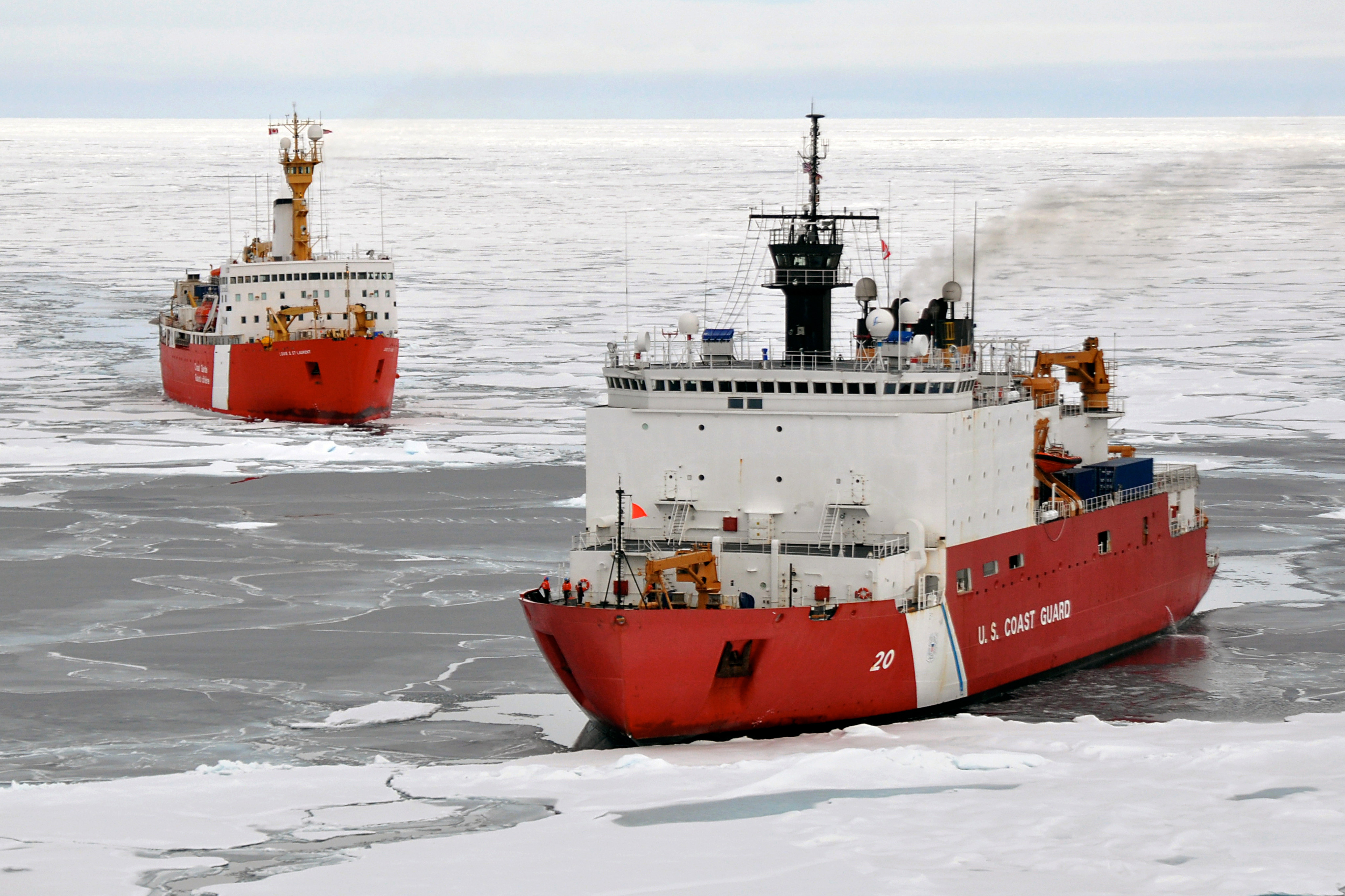
Canada has finished collecting the data it needs to bring its Arctic submission to the UN Commission on the Limits of the Continental Shelf. With the support of the Swedish Icebreaker, Oden, and the Geological Survey of Denmark and Greenland, Canada hopes to show why the North Pole belongs to them.
In 2007 Russia shook the world by planting their flag into the seabed under the North Pole. This created an international flurry over who truly “owned” the North Pole and much of Arctic Ocean. But in today’s day and age, planting a flag is no longer is an acceptable way of claiming ownership; instead scientific rigour and careful diplomacy is needed. This is why almost 10 years later, Canada has finally finished collecting data to map its extended continental shelf in the Arctic. But that is not the end. It will still be two or three years before Canada brings its submission to commission. All that data still needs to be analyzed. And as Mary-Lynn Dickson, Director of Canada’s United Nations Convention on the Law of the Sea (UNCLOS) program, said to the High North News in a recent interview, the application will be, “a thousand pages or more.” What is clear, however, is that Canada’s claim will overlap those already submitted by Russia and Denmark, which means, if all three claims are scientifically accurate and accepted by the commission, diplomatic negotiations will need to occur.
2016 is the last survey planned for Canada’s data collecting phase in the Arctic Ocean. For the last three years, Canada has been collecting data in the Arctic Ocean to see how far the natural extension of Canada’s continental shelf extends. The United Nations Convention on the Law of the Sea is an international agreement that says, “that coastal states have sovereign rights over the natural resources of the seabed and subsoil beyond 200 M as well as jurisdiction over certain activities, such as marine scientific research.” Canada is therefore collecting data to gain sovereign rights over the seabed and subsoil well into the Arctic Ocean.
Multinational Collaboration
Much like any successful operation in the north, Canada’s data collection was not accomplished alone; cooperation was key. And in this case, international cooperation. According to Dickson, several countries played an important role in the expedition, including Sweden and Denmark/Greenland. The Swedish icebreaker, Oden, played a crucial role in aiding the Canadian icebreaker Louis S. St-Laurent navigate the rough and occasionally treacherous northern waters. Furthermore the Geological Survey of Denmark and Greenland, a research and advisory institution, helped the Canadian team dredge rock samples, which was a first for the Canadian UNCLOS program. This process will not only lead to answering several tough scientific questions, but also help create more understanding surrounding the geological history of the Arctic Ocean. As Dickson explained, “there is not a lot of rock samples that have been dredged. It will provide lots of new scientific information about the ages of the rocks, we will be able to understand the composition of the rocks, and we will all be better the geological history of the Arctic Ocean. I think the samples that we collected are going to be pretty exciting and other Arctic countries are going to be excited about the results.”
This new information that was collaboratively collected will hopefully also be used in the submission in 2018. Dickson explained,“[The rock dredging] will provide scientific information that will definitely be included, and hopefully justify the areas that we were able to get rock samples for consist of continental rocks.”
But it was not only the Nordic countries that collaborated with Canada on this scientific survey. The Canadian scientists also collected data for the United States in the Canada basin and the favor was recently returned. As Dickson elaborates, “Good collaboration between Canada and the U.S., we have a rich history on collaborating on Arctic research. We were very happy to work with our U.S. colleagues.”
This is not the end of the collaboration, Dickson said, “Even though we are finished the survey part, our scientists will still be working with the scientist from Denmark and Sweden to analyze this data. We want to continue to collaborate scientifically with them and probably our American colleagues as well.”
The North Pole
Several Arctic countries are claiming the North Pole as their own. In recent news, Denmark declined Russia’s offer of bilateral negotiations over territory in the Arctic Ocean, including the North Pole, which both countries claim. Dickson and her team were out collecting data when this news was made public. “I was aware of [the news],” she said and, “we will make sure we have a scientific case to make for Canada’s submission, we will do this submission right, and like I said we want to get it in sooner rather than later, but we need to do it right.”
According to Dickson,“Yes our submission will include the North Pole.” This means Canada will be in disagreement with both Denmark and Russia on an issue that has brought much international attention. But there is a deeper disagreement within Canada regarding the claim to the North Pole. Professor Michael Byers, Canada Research Chair in Global Politics and International Law, said to Eye on the Arctic earlier this year, “What Canadian officials are telling you in May 2016 is that they are implementing a policy direction given by (former Prime Minister) Stephen Harper in December of 2013.” He then goes on to say, “The reason why Canada will not be able to mount a successful claim to the North Pole is not because of the science, but because the law concerning the maritime boundaries will put the North Pole well off to the Danish side.” Although the science might show that Canada’s continental shelf naturally extends in a way which would allow the “ownership” of the North Pole, there are other layers of international law and diplomacy that must be navigated before the North Pole officially becomes part of any country.
Tough Conditions
What makes this survey all the more impressive is the tough and daunting conditions that the scientists continually work in. “It is so remote, it is so harsh, and the Arctic Ocean, geologically it’s complex ocean.” Even though this year was a light ice year, making collecting data easy, Dickson emphasized that this does not make the process itself easy. “We had some problems on the cruise, losing equipment. That happens when you are going through ice. It’s a tough environment—even when it is light ice, it is a tough environment.”
The members working on the ship, partially due to the light ice, but also due to the nature of the cruise, worked hard. Dickson said, “People work a 12 hour shift for 7 days a week, they don’t get a day off.” But she emphasized above all the importance that the team played in the success of the overall survey. “The team that we have deserve all the credit in the world […] there were some times when it looked bleak […] they were able to recoup and keep us going.”