As federal plans falter, Alaska ports step up their own efforts to serve the Arctic
With the federal government’s work toward creating a U.S. Arctic port stalled, existing Alaska ports from the Aleutian Islands to the Bering Strait will have to push forward on their own to support Arctic vessel activity.
That was the message delivered last week at an Arctic conference in Anchorage. Representatives from the port cities of Nome, Unalaska/Dutch Harbor and St. Paul, along with an official from the Alaska Native corporation that now controls most of the territory at the previously used site of Port Clarence, said their communities all had some claim for the title of the nation’s Arctic port—while also conceding that each site has some shortcomings.
Though the ports compete, to some degree, for the title of Alaska’s Arctic port, the sites all complement each other too, said Ron Philemonoff, Chief executive of Tanadgusix Corp., or TDX, the Alaska Native corporation operator owned by the Aleut people of St. Paul.
“As a team, connecting the dots, I think we’re all better for it if we work together,” Philemonoff said.
The last official Corps of Engineers document on a deepwater U.S. Arctic port was released in February of 2015, a draft that identified Port Clarence and Nome as the likely sites for a future deepwater Arctic Port. A final report, recommending a course of action, was planned to follow. But later that year, after Royal Dutch Shell announced it was abandoning its ambitious offshore Arctic oil drilling program, the corps said it was pausing further planning.
That’s left each port to move forward on its own.
Port Clarence
Port Clarence is the only site with natural deep water (at least 35 feet deep) that is close to shore and near the Arctic Circle. An arcing sand spit partially separates it from the ocean waters and creates a protected bay.
Thanks to those natural features, Port Clarence has a history with the marine industry that goes back to the mid-19th century, said Matt Ganley, vice president of the Bering Straits Native Corp., the indigenous owner of most of the port site’s territory.
Vessels involved in the search for the ill-fated Franklin expedition overwintered at Port Clarence in 1850 and 1852, Ganley said. Shortly after the U.S. purchase of Alaska in 1867, Port Clarence was the home for Western Union’s unsuccessful attempt to put a telegraph line across the Bering Strait, he said. More recently, it was the home of a U.S. Coast Guard navigational station that was decommissioned in 2010. The Coast Guard operations left some good—though abandoned—facilities, like a “beautiful” 8,000-foot airstrip.
And it has long been the place where ships traveling in the Bering Strait region or heading into Nome wait out stormy weather. “They run to Port Clarence, and they always have. They have since 1850,” Ganley said.
What the site does not have, especially after Shell pulled up stakes, is any current economic reason for port development, Ganley said.
“Everybody wants a port in their backyard. But a port is only good if it makes money, saves money or protects money. And at this point in time, we need to look for a reason to make Port Clarence do one or all of those things,” he said.
Without Shell, there is no current economic anchor for Port Clarence, he said. But there is potential for such activity in the future from two mine sites in the area: the Graphite One site to the east, which could produce graphite, and the Lost River site to the west, which produced tin in the past and which could produce a variety of products, including some rare-earth minerals, in the future.
But those mines are stymied by lack of energy, and so are any ambitions for Port Clarence. Bering Straits is also eyeing liquefied natural gas (LNG), Ganley said. The LNG does not have to be produced in Alaska to be of use to Port Clarence, he said.
“LNG makes sense because it’s coming through the strait,” he said. “When it gets down to brass tacks, we don’t care if this LNG comes from domestic sources or foreign sources. If it can work economically, let’s make it work.”
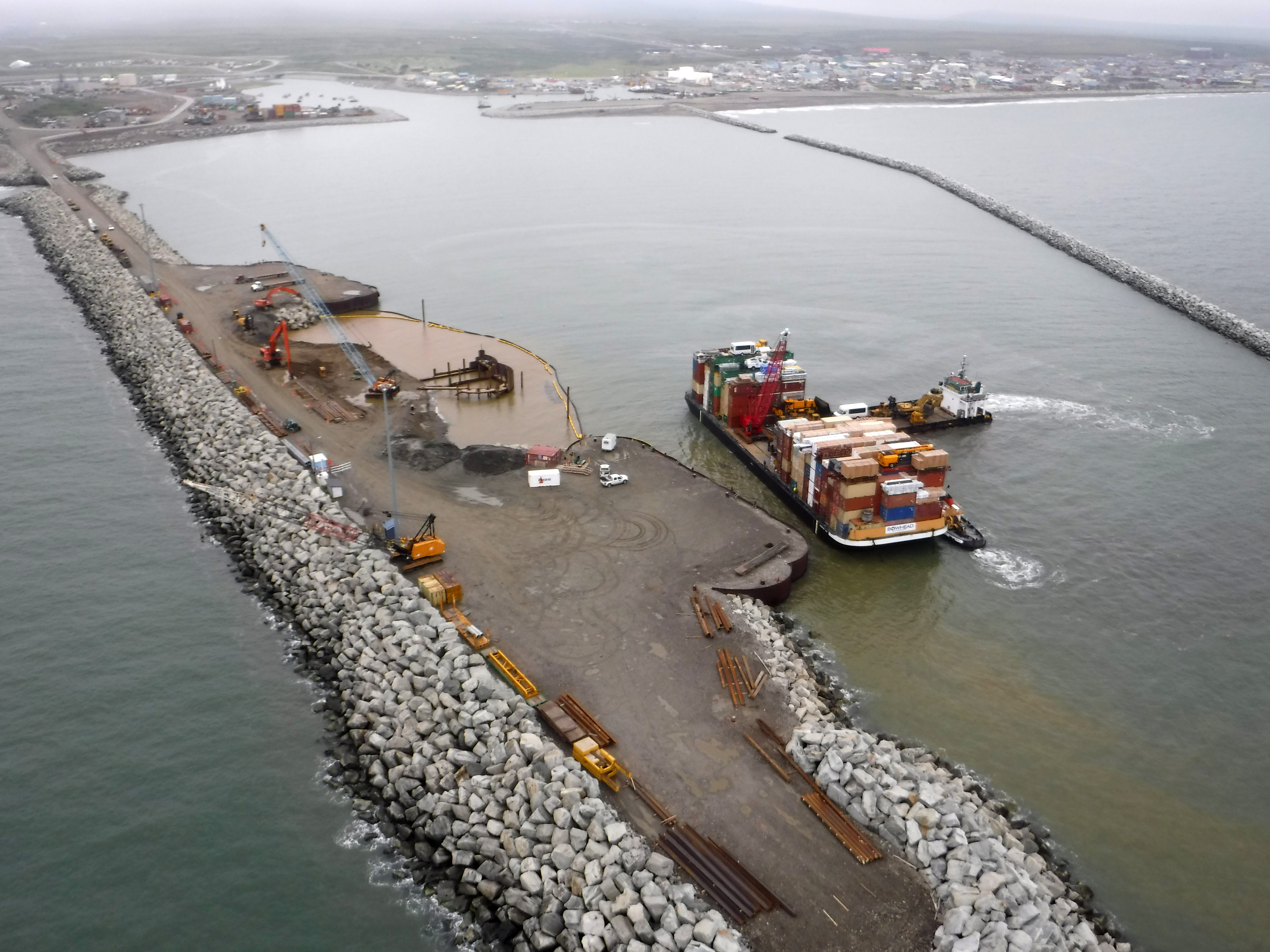
Nome
Garth Howlett of Anchorage-based PND Engineers said the Port of Nome is already deeply involved in Arctic commerce.
Nome has a large and sophisticated hospital, stores, a dual-runway airport, numerous repair shops and a regional seafood industry, said Howlett, whose company does consulting work for the city’s port facility and is helping to guide its ongoing development. The Port of Nome already serves 60 Alaska communities from Utqiagvik (Barrow) in the north to Unalaska/Dutch harbor in the south.
“Nome is well-situated not only to be a good regional port but to be a gateway port to the Arctic as part of a port complex,” Howlett said.
Business has expanded significantly, he said. In 2000, about 160 ships used the port. In 2016, that number exceeded 750, he said. And the vessel type is changing. In the past, small barges dominated, but now there are large barges, military ships, cruise ships, research vessels and others in the mix, he said.
“Not only are there a lot more board, but the boats are getting a lot bigger,” he said.
The port season has expanded as well. Though the port is officially open from June 1 to Oct. 1, it functions from mid-May to December, he said. “Because of the amount of traffic that’s going through here, they’re pushing the envelope more and more every year,” he said.
Facilities have been improved and expanded. There is a new middle dock on the west end of the harbor and a new airbag system that enables vessels to be brought up from the water for service and repairs. “This is kind of a game-changer in a lot of ways. Now a lot of these folks, instead of heading all the way to Seward to get repairs, they can do it right here. They can do it in Nome.”
Those and other features have made Nome a cheaper alternative for overwintering, he said.
What Nome lacks is deep water.
The port is considering dredging options to create deeper waters, he said. But ultimately, deepwater Port Clarence has to remain in the picture, he said.
Dutch Harbor
Dutch Harbor is already known as major Pacific maritime port.
“’The crossroads of the North Pacific,’ that’s one of the things we’ve probably been dubbed,” said Peggy McLaughlin, port director for the city of Unalaska/Dutch Harbor.
Dutch Harbor can claim many superlatives, McLaughlin said.
It is a major hub for global container shipping, the top-volume U.S. seafood port and it’s located directly on the Great Circle Route between Asia and the West Coast of North America. “That’s a straight line. That’s the most efficient way to ship from the West Coast to Asia. And everything goes by Dutch Harbor,” she said.
It’s the only deep-draft port in the Aleutians that is free of ice year-round, the westernmost container shipping terminal in Alaska and the only international container shipping terminal in Alaska, she said. The harbor is in the midst of a $38 million upgrade and expansion, a project that will add 610 feet of dock space, an equivalent amount of new crane line and other features.
However, Dutch Harbor lies about 1,000 miles south of the Arctic Circle.
St. Paul
The port in the Pribilof Islands is in a location that is the “center of the universe,” said Philemonoff, whose company has marine-service subsidiaries.
“It’s our universe. It’s where we all grew up and prospered,” he said.
St. Paul’s position in the central Bering Sea is strategic for Arctic mariners, he said. “We are the last and the very first port that you will leave and see before you hit the ice. We are at the edge; we are the gateway to the Arctic,” he said. That is why local officials boast about the site being 90 percent ice-free rather than fully ice-free, he said.
“We are right in the middle of the action,” he said. “The boats that are going to the Arctic head right past St. Paul.”
With a population of about 500, St. Paul has a harbor, breakwater and facilities with three docks, a 7,000-foot runway, hotels, restaurants and other services, Philomenoff said.
One advantage St. Paul has is an abundance of local energy. That is the result of a big push for wind power, launched when locals became fed up with electricity prices that were running to 55 cents a kilowatt, he said.
“We realized, looking around, that wind energy was a cheap, natural source of energy that was all around us,” he said.
Now St. Paul has an advanced wind-energy system, with three large turbines that provide not just electricity but also heating and thermal plant capability, he said, which functions as something like a form of an energy-storage battery, he said.
St. Paul is smaller than Dutch Harbor and Nome, he conceded. But there is an advantage to the port and the people who work there, one that can help the whole region prepare for the future, he said.
“Unlike some of our best customers and clients, Shell Oil, we’re here for the last 10,000 years and we will be here for another 10,000,” Philemonoff said. “So we have a long-term outlook.”